

Online Registration Closed
The Montana Bureau of Mines and Geology (MBMG) is hosting the 2022 AASG/USGS Data Preservation Workshop. Please review the information provided on this page for details about the workshop, and complete the registration process online by clicking Register Online above.
Our planning team will be reaching out to the potential session speakers.
The agenda also includes opportunities for presenting lightning talks.
Please indicate your interest in giving a lightning talk in the form in the link below:
INTEREST: 2022 AASG/USGS Data Preservation Workshop Lightning Talks
Location:
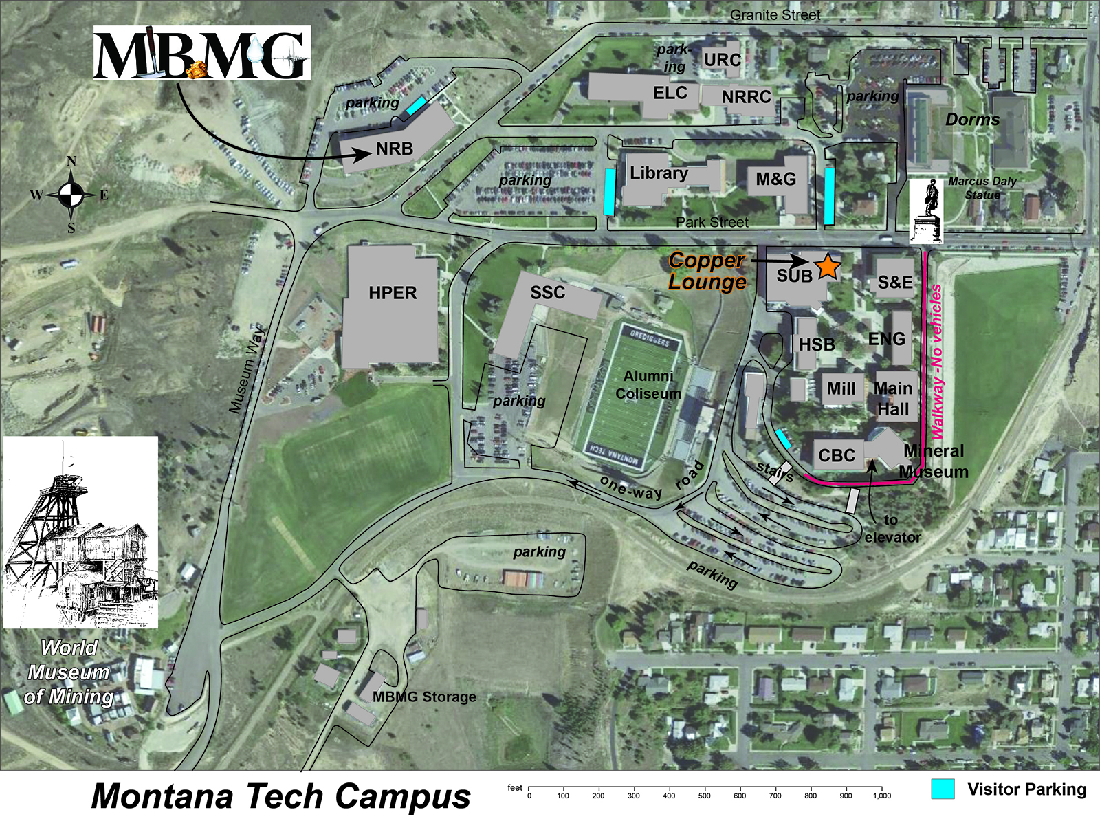
Montana Bureau of Mines and Geology (MBMG)
Montana Technological University
1300 W Park Street
Student Union Building (SUB)
Copper Lounge
Butte, Montana
Registration Fees:
$80 per participant


| 8:30 a.m.– 9:20 a.m. | Welcome, Logistics, Workshop Goals |
| 9:20 a.m. – 10:00 a.m | Participant Introductions: What do you want to get out of this workshop? |
| 10:00 a.m. – 10:20 a.m. | BREAK |
| 10:20 a.m.– 12:00 | Session 1: MBMG Highlights and Activities
|
| 12:00 – 12:15 p.m. | Lightning Talks 1 |
| 12:15 p.m.– 1:15 p.m. | LUNCH |
| 1:15 p.m. - 2:55 p.m. | Session 2: Database, data delivery, and applications, Part 1
|
| 2:55 p.m. – 3:15 p.m. | BREAK |
| 3:15 p.m – 3:35 p.m. | Lightning Talks 2 |
| 3:35 p.m. – 4:40 p.m. | Session 3: FY 2023 Program Announcement and Q&A
|
| 4:40 p.m. - 5:00 p.m. | Day’s Wrap-Up |
| 5.00 p.m. | Social Hour Everyone Welcome |
| 8:30 a.m.– 8:40 a.m. | Daily Logistics |
| 8:40 a.m. – 10:40 a.m. | Session 4: Innovative Repository Design and Practices
|
| 10:40 a.m. – 11:00 a.m. | BREAK |
| 11:00 a.m.– 12:00 | Session 5: Data Preservation for Environmental Equity
|
| 12:15 p.m.– 1:00 p.m. | LUNCH |
| 1:00 p.m. - 4:30 p.m. | Field Trip: An afternoon at the Mining Museum and optional underground tour |
| 8:30 a.m.– 8:40 a.m. | Daily Logistics |
| 8:40 a.m. – 9:00 a.m | Lightning Talks 4 |
| 9:00 a.m. – 10:20 a.m. | Session 6: Digital Capture of Physical Samples
|
| 10:20 a.m. – 10:40 a.m. | BREAK |
| 10:40 a.m.– 12:00 | Session 7: Database, Data Delivery, and Applications part 2
|
| 12:00 - 1:40 p.m. | LUNCH at Mineral Museum (2-minute walk) |
| 1:40 p.m. – 3:00 p.m. | Session 8: Recommended Practices for Document Preservation
|
| 3:00 p.m. – 3:20 p.m. | BREAK |
| 3:20 p.m – 4:40 p.m. | Session 9: Building Capacity and Collaborations
|
| 4:40 p.m. – 5:00 p.m. | Closing Remarks |
Download the following PDF for the list of Lightning Talks to be presented at the 2022 AASG/USGS Data Preservation Workshop.
LightningTalkPresentationOrder-2022.pdf
This PDF file has a checklist for preparing for the lightning talks, tips for a successful presentation, and access to the slides from 2019 lightning talks.
LightningTalkChecklist-2022.pdf
Participants in the optional tour of the underground mine will be required to wear closed toe footwear and long pants. Reflective clothing, self-rescuers, and hearing protection will be provided.
Speaker information is coming soon.
The convective circulation of heated water is a natural consequence of the emplacement of magmas into the intermediate and shallow crust. Interaction between these circulating fluids and their wall rocks produces distinctive patterns of hydrothermal alteration, and these environments host several important styles of hydrothermal mineralization. For examples, porphyry mineralization can form in the near-magmatic environment, and epithermal deposits are characteristic of the shallowest parts of these systems. Oxygen isotope analyses of the hydrothermally altered rocks can be applied as an important monitor of hydrothermal water-rock interaction, and they can provide a useful map of the scale of hydrothermal activity. Stable isotope analyses, coupled with mineralogic studies of the alteration, have been carried out at several large hydrothermal systems (both active and fossil) that are exposed at different erosional levels. These studies can be compiled to construct three dimensional pictures of magmatic-hydrothermal systems from deeper levels to the surface, with special emphasis on caldera-related hydrothermal systems.
The Rico, Colorado, hydrothermal system hosts a deep stockwork Mo deposit and shallower epithermal vein mineralization that produced rich Ag deposits. With deep drilling and steep mountainous topography, the hydrothermal system can be sampled over a vertical interval of nearly 4 km. Stable isotope analyses of the altered rocks show that the hydrothermal effects can be mapped in both host intrusive and sedimentary rocks for more than 5 km from the system’s center (Larson et al., 1994; Meuzelaar, 1996). Shallower examples of large hydrothermal systems that have been examined using stable isotopes include alteration around Eocene plutons in the Idaho batholith (Criss and Taylor, 1983), and 23 Ma hydrothermal system associated with the formation of the Lake City Caldera, Colorado (Larson and Taylor, 1986). In both cases, hydrothermal circulation was strongly controlled by permeable zones that include fractures associated with calderas. Finally, research on the active hydrothermal system at the Yellowstone Caldera provides important information about the shallowest part of large of hydrothermal systems (Larson et al., 2009; McMillan et al., 2018), where fluids rise along the hydrostatic boiling curve through permeable plumbing.
Compiling these examples yields some interesting features of the magmatic-hydrothermal environment. Even at the deeper levels near where magmas are emplaced (~4-6 km), hydrothermal effects can extend kilometers away from the driving heat source for the circulation. Porphyry style mineralization with potassic alteration and a strong magmatic fluid component can form in and around the intrusions. Distal alteration is dominated by ambient groundwater (meteoric in most cases) with a minimal magmatic component. Hydrothermal alteration in these areas is characteristically propylitic with chlorite, albite, calcite, and pyrite as important alteration products, among others. Fluids rise along permeable zones (e.g., fractures, permeable sedimentary units, flow contacts) and ultimately reach the surface where they boil upon rising. The boiling imparts a steep thermal gradient and the drop in temperature can produce drastic changes in fluid chemistry. The shallowest alteration is dominated by clays and can contain sulfate minerals.

This presentation will provide a summary of recent hard rock mining activity around the state and a brief overview about the types of mining projects that are permitted through Montana DEQ. Discussion will include the general duties of DEQ’s Hard Rock Mining Section and an update on current permitting actions for new operation applications and modifications to existing permits. The presentation will conclude with a photo tour of selected sites that represent the wide range of active operating permits that are inspected by DEQ staff. Site summaries may include a discussion of local geology and the associated commodities which contribute to the mineral wealth of the Treasure State.

Mineral deposits of the 2.7 Ga Stillwater Complex in South-Central Montana include modest resources of Ni-Cu disseminated to massive sulfides at the base of the complex, chromitite deposits of the Ultramafic series, the platinum-group element (PGE) deposit of the Johns-Manville (J-M) Reef, and a low grade Pt-Pd deposit known as the Picket Pin deposit, the latter two hosted in the Banded series. However, the only deposit to be commercially mined without government support is the J-M Reef. A review of the proposed models to explain the concentration mechanisms that formed these deposits range from orthomagmatic interpretations involving direct precipitation from a magma to suggestions that igneous hydrothermal fluids both introduced the ore components and modified the mineral assemblage at the magmatic stage.

The Boulder batholith of western Montana was emplaced between ~82 and 75 Ma lies principally in the hinterland or hanging wall of the Laramide fold and zone lying along the eastern Rocky Mountain front.
Here, we present hornblende barometry estimates of the pressure of crystallization Butte Granite unit of the Boulder Batholith, and granitic intrusions of the Pioneer batholith. This method yields estimates approximately 2 kb (corresponding to ~7 km depth) for samples collected from the northern Boulder Batholith (south and southeast of Helena) to the southern Boulder batholith (Butte to Whitehall), and the Pioneer batholith.
The Boulder Batholith in most cases intrudes along its roof the slightly older Elkhorn Mountains Volcanics (~86-82 Ma), which have described thicknesses of up to 3 km. Consequently, the depth estimates based on hornblende barometry differ greatly from the minimum stratigraphic depth of the roof. Folds and local thrust faults locally deform the Elkhorn Mountain Volcanics. In the Wolf Creek quadrangle north of Helena, The 80-74 Ma volcanic and volcaniclastic rocks of the Two Medicine Formation were thrust-imbricated and folded prior to deposition deposition of the Adel Mountain Volcanics 74.7 to 73.7 Ma, which are in turn cut by thrust faults.
A plausible explanation for the 7 km depth of emplacement of the upper part of the Boulder Batholith is that the batholith was emplaced into a thrust-imbricated, folded and thickened section of Elkhorn Volcanics. The timing of shortening must therefore be in a narrow time window between erupted of the Elkhorn Mountain Volcanics and emplacement of the Boulder Batholith.
Exhumation of the Boulder Bathoilth from ~7-9 km depth to ~2-5 km depth occurred in the Butte area between ~66 Ma and 62 Ma, and continued exhumation brought rocks to the surface prior to deposition of the base of the Lowland Creek Volcanics at ~52 Ma. These relationships suggest that Laramide shortening extended from ~80-75 Ma to <62 Ma, and but that exhumation was largely accomplished after Boulder Batholith magmatism largely ceased at ~75 Ma.

Discovered in 1882, the Black Pine mine was developed into an important silver mine. The initial production was in November 1885 when 400 tons of ore were shipped to the Hope mill in Philipsburg. With the value of the mine demonstrated, the Black Pine Mining Company was incorporated in October of 1886. Although the Black Pine Mining Company failed, the mine went on to be successfully worked by the Combination Mining and Milling Company producing over 2 million ounces of silver. Subsequently, many other mining companies operated the mine that eventually produced a total of 5,622,000 ounces of silver, 3,000 ounces of gold, 10,678,000 pounds of copper, and small amounts of lead and zinc. Since 1900, the mine was noted for producing unusual minerals. In the 1980s many rare minerals were discovered at the mine. Mineralogists have continued to identify rare minerals in specimens preserved from this mine including three minerals that are new to science. Also, many of the rare minerals from the mine are well crystalized. The Black Pine mine is a world class mineral locality with a total of 79 different mineral species being confirmed from the deposit. This paper explores the mine history and the unique mineralogy of the Black Pine mine.

This presentation covers investigations of mineral resources in the 7.5' Elkhorn Quadrangle as part of the Earth MRI project funded by the USGS. Most mineral deposits occur in the Elkhorn mining district. Mineral deposit types consist of a porphyry system, breccia pipe, skarns, and carbonate replacements. The porphyry system was not developed into an operating mine because of low molybdenum grades. Most metal production was extracted from skarn and carbonate replacement deposits. The skarn deposits were explored for gold resources from 1980 to 2013. The last mine in the district was developed from 2011 to 2013 for a skarn hosted gold resource.

Magmatic-hydrothermal ore deposits including porphyry copper deposits (PC) and iron oxide copper gold (IOCG) deposits are often considered as unrelated types of crustal systems to sediment-hosted ores. This dissociation is due in part to lack of a comparative geochemical framework which depicts the composition of ore-forming fluids spanning both magmatic sources and hydrocarbon, brine, and meta-sedimentary fluids. Without understanding how magma and sediment-driven fluids may comingle, exploration for sediment-hosted PC deposits in the Sevier fold and thrust belt will remain poorly informed by science. Phase diagrams used to describe porphyry copper deposits cannot show hydrocarbon species as the common coordinate axis are sulfur and oxygen fugacity without any provision for organics, and hence are irrelevant to sediment-hosted ores. This dichotomy is in part a hard-rock versus soft-rock division in geology but it persists in professional specialization within industrial sectors of materials (metals and mining) versus energy (oil and gas) thus divorcing ore genesis from petroleum geology even splitting science from engineering. Today, clean sustainable green energy by decarbonization and electrification of the US economy requires transformative solutions without limitations imposed by historic subdivisions. Newly-mined critical and basic minerals-especially copper are needed to sustain production of electric vehicles, semi-conductor electronics, magnets, and lithium storage at an unprecedented level of demand.

The Radersburg (aka Cedar Plains or Crow Creek) mining district is located approximately 90 highway kilometers southeast of Helena, Montana. The district produced far in excess of the reported 10,109 kilograms of gold (325,000 oz.) with an average tenor of 26.4 g/tonne Au (0.77 opt Au), and is also credited with an additional 8,087 kilograms of silver (260,000 oz.) and small amounts of copper, lead and zinc production (Klepper, Rupell, Freeman and Weeks, 1971). The author entered the district in 2019 to find surprisingly encouraging economic geology characteristics, but no current activity by competitors. Subsequent reconnaissance visits confirmed the initial favorable impressions regarding the geological model, and eventually several lode claims were strategically staked after careful structural and satellite analysis. Ongoing work continues including geologic mapping of structure, petrology, alteration, sampling, and obtaining and evaluating public and private database resources.

This paper contrasts the lack of government assistance to exploration and mining in the U.S. with those active programs of Canada and Australia. It traces the origins and operations of the Department of Interior’s short-lived mission to assist prospectors and miners with mineral exploration and development after World War Two. Initially driven by the need to find strategic and critical materials and uranium to help power the new Atomic Age, the Defense Minerals Administration (DMA) was launched under authority of the Defense Minerals Production Act of 1950. Certain minerals, including asbestos, uranium, industrial diamonds, PGMs and iron ore were eligible for up to 90% federal participation.

Montana contains a great variety of metallic mineral deposits that span a huge time range, from the Archean to the recent. Most of the major mines have been studied for many years, and quite a bit of data already exist on the stable-isotope composition of sulfur in the deposits. As well, the author and his students, in collaboration with Dr. Simon Poulson of the University of Nevada-Reno, have collected new S-isotope data on many deposits in western Montana. Some general trends based on a review of the published and unpublished data include the following:

The average crustal abundance of Ba is roughly 250 ppm (Hanor, 2000), however, the Yellowstone volcanic system has produced several units with concentrations of Ba well in excess of this. Whole-rock analyses of the Huckleberry Ridge Tuff Member C, Canyon flow, and tuff of Sulphur Creek all have Ba concentrations generally over 1 wt% (Pritchard and Larson, 2012; Larson et al., 2009). Of those three units, the tuff of Sulphur Creek (Tsc) was studied due to the exposure of hydrothermally altered rocks in the Grand Canyon of the Yellowstone River. Approximately 300 m of the Tsc has been exposed (Larson et al., 2009). Moreover, this section has also been pervasively altered by circumneutral and acid-sulfate fluids leading to pervasive argillic and locally advanced argillic alteration (Larson et al 2009). The relative uniformity of a single unit being altered allows for a study of the mobility and sequestration of Ba in such an environment. Most of Ba in the unaltered rock is concentrated in original magmatic K-feldspar phenocrysts, with minor amounts in magmatic oligoclase phenocrysts (Pritchard and Larson, 2012). Additionally, volcanic glass from the Tsc has up to twice the average crustal abundance of Ba (Pritchard and Larson, 2012). In the deepest exposed portions much of the original magmatic material has been replaced by illite, quartz, and, in upwelling areas, hydrothermal feldspars, including hyalophane ((K,Ba)(Al,Si)4O8) (Larson et al 2009). Hyalophane is the only Ba-bearing phase in this section, and for approximately 100 vertical m. While hyalophane does uptake a significant amount of Ba, some almost certainly escapes into the fluid and can be noted as elevated in thermal fluids from some circumneutral springs. Above the oxidation limit, where kaolinite becomes the dominant clay mineral, there are two Ba-bearing phases, baryte (BaSO4) and walthierite ((Ba.05Al3(SO4)2(OH)6), which are both commonly associated with vuggy silica. However, they are rarely found together. As H2S volatilizes from a boiling water table, it condenses and oxidizes while mixing with relatively pure, cool meteoric water, generating an acid-sulfate fluid (White et al., 1971; John et al., 2018). The acid-sulphate fluid attacks the rock, leaching any Ba still remaining in weakly altered rock before it is quickly precipitated as baryte or walthierite. While true paragenetic relationships have yet to be established, baryte is presumed to be an earlier phase associated with illite and Fe-sulfides from upwelling zones whereas walthierite crystallized in cooler portions associated with increased kaolinite content.
Argillic and localized advanced argillic alteration redistributed Ba concentrations in the Ba-rich tuff of Sulphur Creek (Tsc). In Seven Mile Hole, Yellowstone National Park, between Washburn Hot Springs and the Grand Canyon of the Yellowstone River, approximately 300 m of altered Tsc is exposed. The area has been altered by circumneutral fluids creating pervasive illite + quartz with hydrothermal feldspars in upwelling zones as well as acid-sulfate fluids generating pervasive kaolinite +/- sulfate. Acid-sulfate alteration is most pronounced at higher elevations and in the South Fork of Sulphur Creek, extending to the Grand Canyon where it can be found overprinting early circumneutral alteration. Circumneutral alteration is best seen 100 m below the current canyon rim on a topographic high between the canyon rim and Yellowstone River. This high is interpreted as a major upwelling zone with illite, quartz, and hydrothermal feldspar. Circumneutral fluids weakly altered the Tsc, occasionally leaving sanidine phenocrysts relatively unaltered. Replacing Ba-rich material with clay in reducing conditions, such as those in deep circumneutral conditions, keeps the Ba in the aqueous phase. As a result, it migrates into more permeable areas, like veins where conditions are feldspar-stable, evidenced by the various hydrothermal feldspars, notably hyalophane ((Ba0.5,K0.5)Al(Si,Al)3O8). Which hydrothermal feldspar is deposited likely depends on the cation ratios (K+/H+, Ba2+/2H+, etc.). Given the right conditions, hyalophane becomes the first sink for Ba and only sink in this regime. Higher up in the system conditions become more acidic and oxygenated leading to production of H2SO4, typical of acid-sulfate fluids. These conditions are likely exacerbated in the South Fork of Sulphur Creek due to the juxtaposition to the highly permeable caldera margin. As the boiling water table is lowered, the pervasive alteration from acidic fluids extends to greater depths. The acidic fluids more completely alter weakly altered rock, releasing much of the Ba remaining in sanidine. However, now there is abundant sulfate in the fluid and Ba is quickly sequestered as walthierite ((Ba0.5□0.5Al3(SO4)2(OH)6) and baryte. Walthierite is usually found with other alunite group minerals where, similarly to the hydrothermal feldspars, speciation is likely controlled by cation ratios. Pseudocubic habits indicate these alunite group minerals precipitated in steam-heated conditions potentially generated from a descending water table. Baryte is found in veins and veinlets near clusters of marcasite and pyrite but is seemingly paragenetically younger. Baryte and walthierite are typically found from the canyon rim to about 100 m below the rim with the most occurrences in vuggy silica in the South Fork of Sulphur Creek. However, walthierite was found on the topographic high with hydrothermal feldspars, potentially indicating waning fluid flow or perhaps deep oxidation to produce the necessary sulfate.

Lodging Information Rooms blocked at the following hotels “USGS NGGDPP Workshop”
Motel 6 – 1.4 Miles, Call 406-723-4391, $92.80/$87.40 includes tax - 220 N Wyoming St
Super 8 by Wyndham – 3.3 Miles, Call 406-494-6000, $111.59 plus tax - 2929 Harrison Ave
Finlen Hotel – 1.4 Miles, Call 406-723-5461, $96 plus tax -100 E Broadway St, On www.finlen.com , click the “BOOK” button. From the “Advanced Options” dropdown menu, choose “I have a group number.” Enter USGS22 (case sensitive).
Best Western Plus Butte Plaza Inn – 3.5 Miles, Call 406.494.3500, $96 plus tax - 2900 Harrison Ave
Fairmont Hot Springs & Resort - 12 Miles, Call 406-723-4391, $259 plus tax and resort fees - 1500 Fairmont Road Fairmont, MT
Holiday Inn Express & Suites - 3.1 Miles, Call 406.782.2000, $199 plus tax - 2609 Harrison Ave Holiday Inn Express & Suites
Fairfield Inn & Suites Marriott - 3.4 Miles, Call 406.494.3000, 2340 Cornell Ave Fairfield Inn & Suites Marriott
America’s Best Value Inn (Rocker) - 2.4 Miles, Call 406.723.5464, 122001 W Browns Gulch Rd
La Quinta Inn & Suites - 3.5 Miles, Call 406.494.6999, 1 Holiday Park Dr. La Quinta Inn & Suites
Hampton Inn - 3.6 Miles, Call 406.494.2250, 3499 Harrison Ave La Quinta Inn & Suites
Copper King Hotel & Convention Center - 4.8 Miles, Call 406.533-6960, 34655 Harrison Ave Copper King Hotel & Convention Center
Red Lion Inn (Rocker) - 2.6 Miles, Call 406.782.5678, 122005 Nissler Rd Red Lion Inn
Comfort Inn - 3.1 Miles, Call 406-723-4391,2777 Harrison Ave Comfort Inn
Days Inn - 3.2 Miles, Call 406.494.7000, 2700 Harrison Ave
Ramada Inn by Wyndham - 3.3 Miles, Call 406.494.7800, 2100 Cornell Ave Ramada Inn by Wyndham
Copper King Hotel & Convention Center - 4.8 Miles, Call 406.533-6960, 4655 Harrison Ave
For a map of hotels and links to their websites, please click on the Trip Advisor link below.
| Mineralogy, stable isotope, and fluid inclusion study of the polymetallic porphyry(?)-lode deposits of Philipsburg, Montana, Beaucamp, C. |
|---|
| Structural analysis reveals wrench-fault controls of vein systems and new ore Resource in the Radersburg District,Byington, C. |
| Geohazards of Jefferson County, MT,,Gavillot, Y. |
| Skarn mineralization, geology and geochemical exploration: JWD lodes Jefferson County, Montana, USA Boulder Mining District,Gavillot, Y |
| Mineralogy and fluid inclusion study of the Marget Ann mine; a gold-rich vein on the northern edge of the Butte district.,Ostenburg, T. |
| USGS Earth-MRI critical minerals program mapping/materials. Update on Elkhorn 7.5’ mapping (field sheets + sketch strat column).,Scarberry, K. |
| Recent earthquake clusters in Stanley, ID.,Stickney, M. |
| Lithogeochemical Evaluation of Hydrothermal Alteration in the Scatter Creek Formation,Ferry Co., WA,Stanfield, J. |
| Geology and an update on mining activity at the Lucky Friday Mine, Idaho,Redgrave, Marisa. |
| The fate of barium in a geothermal area, Yellowstone National Park,Zimmerman, Jarred. |
Listen to Butte stories:
Butte attractions
Mineral Collecting
Hiking
Westward Expansion State and National Parks
Historic Mining Related Sites
Native American History State and National Parks
Nearby National Park Service Sites
Developed Hot Springs
Dinosaur Sites:
Geology:

View of Elkhorn Peak

Windy Point 4 - Elkhorn Field