Surface Water Assessment and Monitoring Program—SWAMP
Introduction
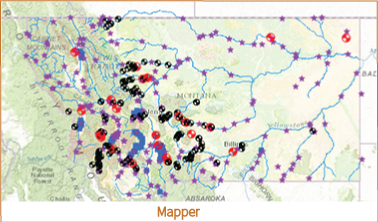
SWAMP is a joint program initiated by the Department of Natural Resources and Conservation (DNRC) and the Montana Bureau of Mines and Geology to collect real-time streamflow data and conduct watershed assessments to aid decision making and policy development in Montana. While data collection, compilation, and dissemination are critical in the short term, these data provide important information to support watershed studies aimed at constructing predictive models of surface-water and groundwater resources subject to development and climate change. Watershed studies conducted under this program will provide opportunities for applied research and training for students of the Montana University System.
Target Audience
The information is needed by a wide range of consumers, including but not limited to: water commissioners; water-right holders; reservoir operators; irrigation districts; recreationalists; local watershed groups and conservation districts (drought management planning); MBMG (groundwater studies); Department of Fish, Wildlife and Parks (instream flows); and the Department of Environmental Quality (water-quality monitoring), Department of Transportation, and other State and Federal agencies.
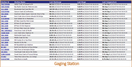
Data Update Frequency
New data are made available every 30 minutes (at 15 and 45 minutes past the hour).