USGS Topographic Maps for Montana


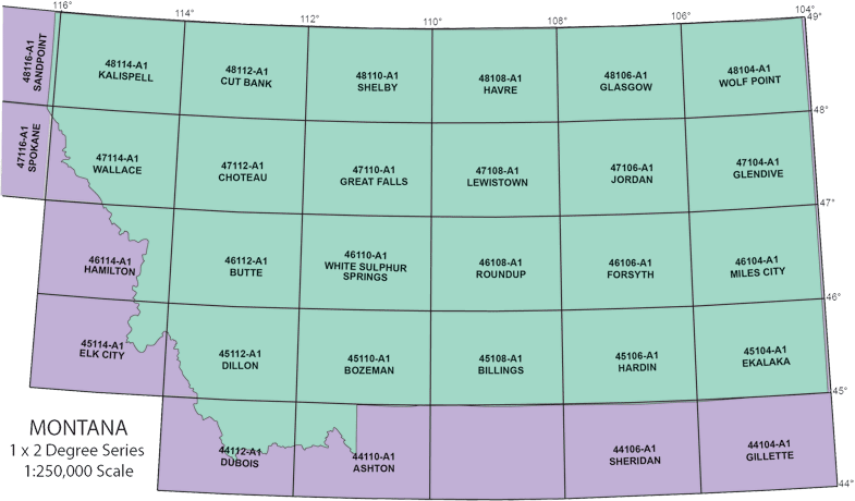
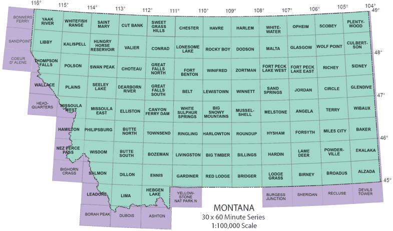
Index to 1° x 2° (250K) maps

indices to 250k Montana topo  maps


Index to 30 x 60-minute (100K) maps

indices to 100k Montana topo maps


Degree blocks for the western half of Montana

These images are a key to the the degree blocks that contain the indices to the USGS 7½' (24K) maps. Point and click on the area of interest.

west half of state block 48115 block 48114 block 48113 block 48112 block 48111 block 48110 block 47115 blockn 47114 block 47113 block 47112 block 47111 block 47110 block 46114 block 46113 block 46112 block 46111 block 46110 block 45114 block 45113 block 45112 block 45111 block 45110 block 44113 block 44112 block 44111


Degree blocks for the eastern half of Montana

These images are a key to the the degree blocks that contain the indices to the USGS 7½' (24K) maps. Point and click on the area of interest.

east half of state block 45104 block 45105 block 45106 block 45107 block 45108 block 45109 block 46104 block 46105 block 46106 block 46107 block 46108 block 46109 block 47104 block 47105 block 47106 block 47107 block 47108 block 47109 block 48104 block 48105 block 48106 block 48107 block 48108 block 48109


Miscellaneous Maps

Misc 20

$16.00

Montana (State) topographic map—Shows counties, location and names of all cities and towns, railroads, township and range lines, rivers and water features, highways, contours, national parks, forests, monuments, wildlife refuges and Indian Reservations (by color pattern). 1965. Scale 1:500,000

Misc 17

$16.00

Montana (State) base map—Shows counties, location and names of all cities and towns and most of the smaller settlements, railroads, and township and range lines (black), water features (blue), 1983 (Revised) Scale 1:500,000. This map does not show contours.

Misc 21

$9.00

Montana (State) base map. Same features as Misc 17, but published in black and white. Scale 1:1,000,000

Misc 22

$9.00

Montana relief map. Overprinted on a modified base map which shows state and county boundaries, railroads, cities, towns and county seats (black), water features (blue). The physical features are highlighted by shaded relief in color, 1965. Scale 1:1,000,000. The map does not show contours.


National Park Maps

N-4408

$7.00

Topographic map of Yellowstone National Park. 1961. Scale 1:125,000

N-4813

$7.00

Topographic map of Glacier National Park. 1968. Scale 1:100,000