| Navigation | Equipment | Culbertson | White Cliffs | Great Falls | Gates of the Mountains | Three Forks | Beaverhead Rock | Pompeys Pillar | Terry |
Lewis and Clark in Montana — a geologic perspective
Culbertson—entering Montana
 Despite
near-freezing temperatures on the morning of April 27, 1805, Meriwether
Lewis completed his celestial observations at the mouth of the Yellowstone
River. The Lewis and Clark Expedition then continued up the Missouri.
Dangerous headwinds forced the canoes ashore about noon. At 4 pm
the expedition continued upstream again, making camp just inside
present-day Montana.
Despite
near-freezing temperatures on the morning of April 27, 1805, Meriwether
Lewis completed his celestial observations at the mouth of the Yellowstone
River. The Lewis and Clark Expedition then continued up the Missouri.
Dangerous headwinds forced the canoes ashore about noon. At 4 pm
the expedition continued upstream again, making camp just inside
present-day Montana.
On April 28, Clark walked along the river bluffs:
. . . the hills & Bluffs Shew the Straturs of Coal, and burnt appearances in maney places, in and about them I could find no appearance of Pumice Stone . . . the Bluffs in this part as
also below Shew different Straturs of Coal or carbonated wood, and "Coloured earth", such as dark brown, yellow a lightish brown, & dark red &c.
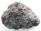
Photo by Ginette Abdo, MBMG
The coal is lignite in the Tongue River Member of the Fort Union Formation. The “burnt appearances” likely refer to areas of clinker (local residents also call it scoria); clinker forms when a burning coalbed “bakes” adjacent shale and claystone.
|
| Photo by Ginette Abdo, MBMG |
Lewis and Clark called
any light-weight, frothy-looking rock with numerous pores or
holes “pumice
stone.” Like clinker, it is produced when coalbeds
burn, and is not of volcanic origin as the captains thought.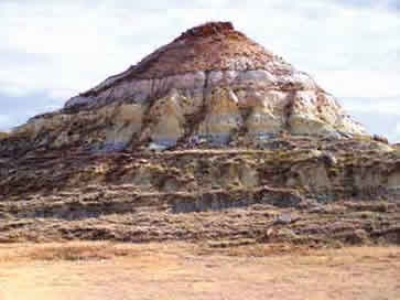
The "Coloured earths" were outcrops of siltstone, mudstone, and soft sandstone in the Fort Union Formation.
Photo by Ginette Abdo, MBMG
Lewis, April 28, 1805
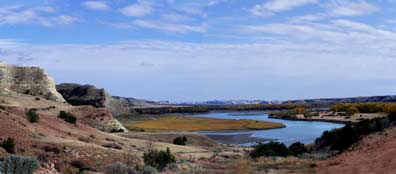
. . . the country through which we passed today is open as usual and very broken on both sides near the river hills, the bottoms are level fertile and partially covered with timber.
Photo by Ginette Abdo, MBMG
Later the 28th Lewis noted:
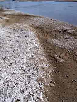
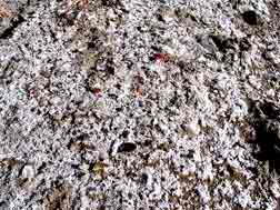
. . . the salts still increase in quantity; the banks of the river and sandbars are incrusted with it in many places and appear perfectly white as if covered with snow or frost.—
 The captains had observed salt areas as far downstream
as the Kansas River and had described “salines” (usually
salt springs) in Missouri, Kansas and Nebraska. The quantity
and extent of salt noted today far exceeded anything seen
earlier.
The captains had observed salt areas as far downstream
as the Kansas River and had described “salines” (usually
salt springs) in Missouri, Kansas and Nebraska. The quantity
and extent of salt noted today far exceeded anything seen
earlier.
 Photos
by Ginette Abdo, MBMG
Photos
by Ginette Abdo, MBMG
This salt is not sodium chloride (common table salt), but a variable combination of sodium, magnesium, and calcium plus sulfate and bicarbonate. Groundwater that passes through rocks and sediments dissolves some of the salts they contain. When that water returns to the surface (usually on a river shore or cliff face) and evaporates, salt crystals and crusts develop.
On April 29, Lewis opted to walk on shore:
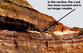
This photograph shows coal on the same level
with clinker. The coal (to the left), which ends
abruptly about photo center, is the unburned
portion of the coal bed.Photo courtesy of Ed Heffren, BLM State Office, Wyoming
The Fort Union Formation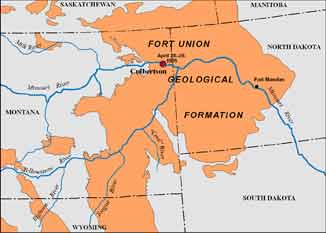
The coal-bearing Fort Union Formation underlies large areas of Montana, North Dakota, and Wyoming.
About 65–55 million years ago, rivers flowing east from the rising mountains deposited alternating sequences of sand, silt, and clay; these sediments ultimately consolidated into soft rock. The coalbeds originated in swamps along the rivers as decaying vegetation accumulated and slowly turned to peat.
MBMG
An ever-changing river . . .Lewis, April 29, 1805:
we came too this evening in the mouth of a little river, which falls in on the Stard. side. . . .This stream . . . Capt. C. named Marthas river . . .
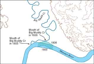
On Lewis’s return down the Missouri River, August 7, 1806 he wrote:
MBMG
Marthas River is Big Muddy Creek. The
creek likely had found a new entrance to the Missouri during
the spring of 1806. Meander development by both streams allowed
high water to cut a passage between them a quarter of a mile
downstream from the creek’s former mouth.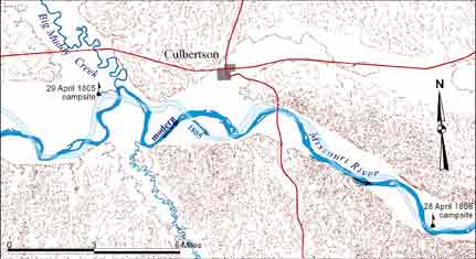
Rivers are dynamic systems — constantly shifting their course through erosion and deposition. The light blue pattern depicts the course of the Missouri River as Lewis and Clark mapped it. The dark blue pattern shows the Missouri’s modern course.
The river’s many course changes since 1805-06 have destroyed most of the expedition’s campsites.
MBMG
| Navigation | Equipment | Culbertson | White Cliffs | Great Falls | Gates of the Mountains | Three Forks | Beaverhead Rock | Pompeys Pillar | Terry |