The seismograms displayed are from selected seismograph stations routinely recorded by the Montana Bureau of Mines and Geology Earthquake Studies Office. Some of the stations displayed are operated by other institutions, such as the US Geological Survey. Using digital seismic data, Webicorders simulate older analog “Helicorder” seismograms, historic paper records recorded on slowly rotating drums. The webicorders show greatly amplified ground movements at a seismograph station during 24 hours. The seismogram is “read” like a book, each line—from left to right and down the page—represents increasing time. As with a book, the right end of any horizontal line “connects” with the left end of the line below it. Examples below illustrate different types of events recorded on webicorders.
The vertical lines are spaced at 1-minute intervals. The time of day (hours:minutes) is indicated in the left margin in Mountain Daylight Time (on the hours) and at the right margin in Universal Coordinated Time (Greenwich Time; on the quarter hours).
Time is indicated at the right end of some of the lines of the plot in local time (Mountain Standard, Oct.-Mar., or Mountain Daylight time) and at the left end in Universal (or Greenwich) time UTC.
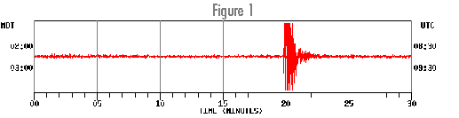
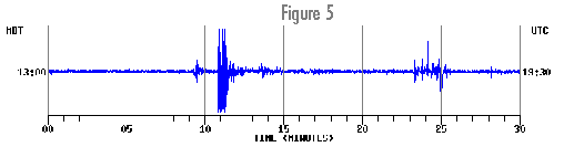
When an earthquake occurs, a webicorder will show ground motions that typically last from several tens of seconds to many minutes depending on the earthquake magnitude, distance, and the sensitivity of the seismograph. The height (amplitude) of the recorded waves on the webicorder is a greatly magnified (50,000 times or more) representation of the actual ground motion. An earthquake recording has recognizable characteristics. Typically, the initial wave is the P wave, the fastest traveling wave, followed by the slower traveling S wave.
The webicorders show local earthquakes in the northern Rocky Mountains and larger earthquakes worldwide. Most global earthquakes of magnitude 5.5 or larger will be visible on the webicorders. For help in determining where the earthquakes that you may observe are located, check the USGS National Earthquake Information Center. The Montana Bureau of Mines and Geology contributes all earthquakes from Montana and surrounding areas to this page (exclusive of Yellowstone, which is monitored by the University of Utah Seismograph Stations https://quake.utah.edu/earthquake-center).
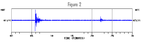
Some types of seismic waves—for example surface waves from a distant earthquake—will be most visible on webicorders generated from broadband seismometers, which are sensitive to low-frequency ground motions. For distant earthquakes, look at one of the broadband stations like BOZ (Norris seismic vault west of Bozeman) which is well suited for recording low-frequency ground motions generated by large, and usually distant, earthquakes (see examples).
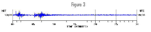
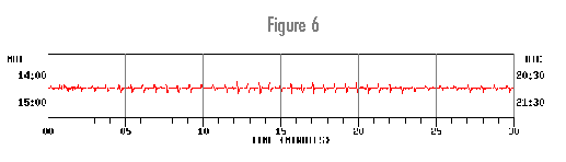
Not all the wiggles seen on the webicorders are due to earthquakes. Seismograph stations record anything that produces ground vibrations, for example, a car or train that passes by the seismic station (we try to locate most of our seismic stations well away from cultural activity), wind, or thunder. Montana seismograph stations also record blasts [link to webicorder snippets showing blasts] generated by open-pit mining operations throughout the region.
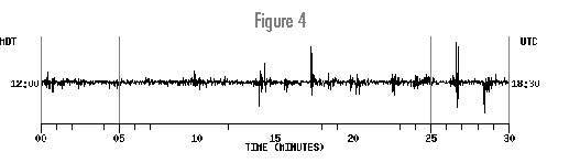
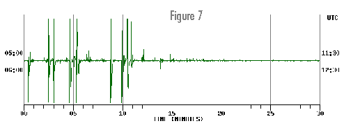
Sometimes the telemetry (communications) between link the field station and the recording lab experiences interference or other problems. Such noise is usually easy to distinguish from earthquake-generated signals because the noise is often persistent “spikey” in appearance (see samples). The USGS also has an illustrated guide for interpreting webicorders: https://youtu.be/SkfR4GBEIp8.