West Crane Buried Valley Aquifer, Sidney, Richland County
Background
The Lower Yellowstone Buried Valley (LYBV) aquifer forms an important water resource in eastern Montana. The sand and gravels of the LYBV form a complex aquifer system, with some areas capable of supporting high-yield irrigation wells and the municipal water supply to the city of Sidney. It also underlies the irrigated farmland in the Yellowstone River valley near Sidney and underlies dryland farmland. In the upland setting, the aquifer is referred to as the West Crane aquifer, where there is the greatest interest in irrigation development. The aquifer underlies land traditionally used to grow dryland crops until its discovery in 2007. Since then new irrigation wells have caused concern about the aquifer's capability to support groundwater development.
Purpose
The project purpose is to estimate how much groundwater can be sustainably developed for irrigation out of the West Crane segment of the Lower Yellowstone Buried Valley aquifer without significantly affecting groundwater and surface-water resources.
Project Scope
Exploratory drilling helped better define the aquifer boundaries and extent. Aquifer tests provided estimated values of hydraulic conductivity (K) and storage coefficient (S), as well as improve definition of the aquifer boundaries. Groundwater-level hydrographs were interpreted to assess potential sources of recharge. The project included water-quality characterization to assess the suitability of groundwater for irrigation. A groundwater flow model was developed to test scenarios on irrigation potential and effects to the hydrogeologic syste.
Results
The model provides a framework for simulating the availability of groundwater in specific local areas as well as throughout the West Crane aquifer. Predictive simulations using the model indicate that utilization of the aquifer for agricultural irrigation will have only minor impacts to surface-water discharges and minimal impacts to riparian evapotranspiration. A simulation of a surface infiltration managed aquifer recharge project predicts that the additional recharge would primarily increase groundwater stored in the aquifer but would also secondarily drive some increased discharge from the aquifer to streams.
Project Reports
- Groundwater model of the West Crane aquifer, Richland County, Montana
View Report - Hydrogeology and irrigation potential of the West Crane aquifer, Richland County, Montana (Reiten, J., and Chandler, K., 2023)
View in Catalog - West Crane aquifer test summaries, Richland County, Montana (Reiten, J., and Chandler, K., 2021)
View in Catalog - West Crane buried valley aquifer: A hidden resource (Chandler, K., and Reiten, J., 2020)
View in Catalog
Download report (18.9 MB)
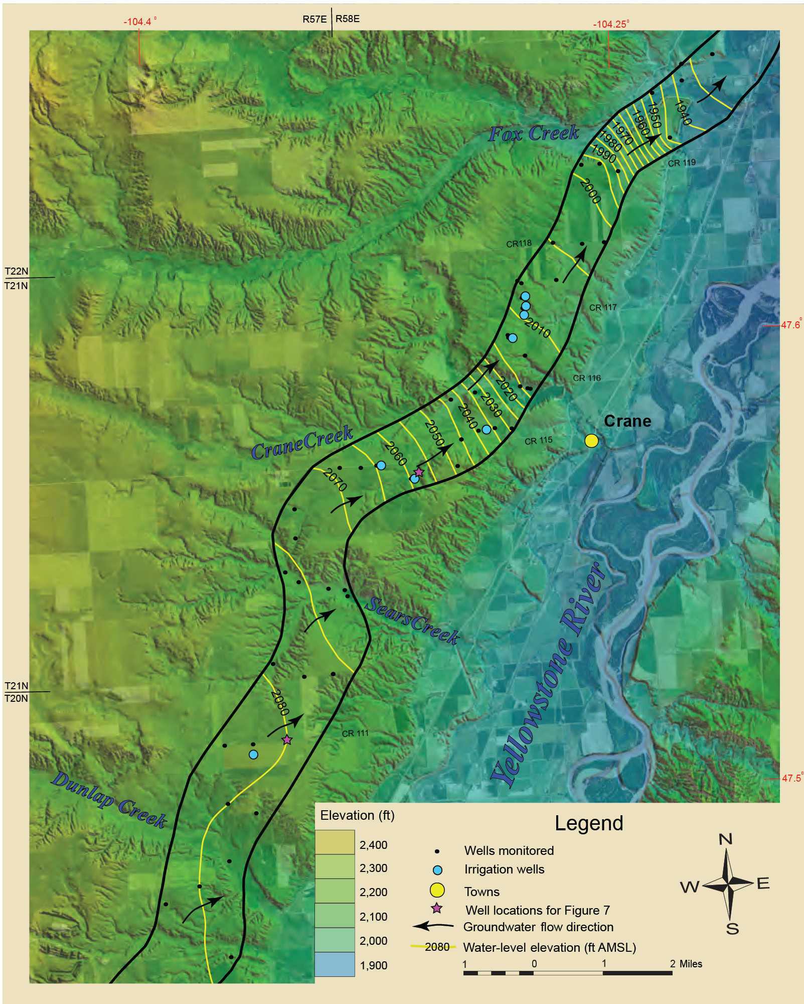
Download plate 1: West Crane monitoring sites and potentiometric surface (270.7 MB)
Download plate 2: West Crane surficial geology (18.4 MB)
Download plate 3: West Crane longitudinal profile with hydrographs (4.4 MB)
Download report (6.2 MB)
Download report (2.76 MB)
Presentations
We have no presentations regarding this project for you to view at this time.Link to Project Data
Data collected for this project can be accessed through the Ground Water Information Center (GWIC) database:
Download project data from GWIC
Program Resources
Contact Information
Program Information
Ginette Abdo, GWIP Manager
(406) 496-4152 | Email