Upper Gallatin River, Big Sky Canyon Area,Gallatin County
Background
In recent years, the Big Sky, Montana area has undergone rapid growth and development as a destination resort and tourism community, with increases in both seasonal and year-round residency (Rose and Waren, 2022). This rapid growth has challenged the ability of resource managers to supply enough water and manage wastewater produced by the growing population.
The area is serviced by private wells, public water supply wells, and individual and community sewage disposal systems. The increase in septic drain fields prompted concerns about groundwater degradation and water-quality effects on the Gallatin River. In addition, late summer algal blooms have occurred over the past 5–10 years in the upper Gallatin River https://gallatinrivertaskforce.org/water-monitoring/. Algal blooms can result from excess nutrients in combination with warmer water temperatures and other factors (Gallatin River Task Force, https://gallatinrivertaskforce.org/2021/11/09/a-river-in-bloom/ river-in-bloom). Increased nutrients from septic discharge to groundwater may be a contributing factor to these algal blooms.
Purpose
The Gallatin River Task Force (GRTF) proposed this GWIP project to better understand the impacts of recent and future development on water quality and quantity.
The primary objectives of this study are to:
- Characterize the quality and quantity of water resources in the study area. This includes groundwater resources used for domestic and commercial supplies.
- Delineate the groundwater flow system and assess the interaction between groundwater and surface water with a specific focus on groundwater/surface- water exchange between the alluvial aquifer and the Gallatin River.
- Evaluate the potential for septic effluent to degrade the Gallatin River by modeling groundwater flow paths from potential nutrient sources to the river and its tributaries.
Project Scope
Study Area
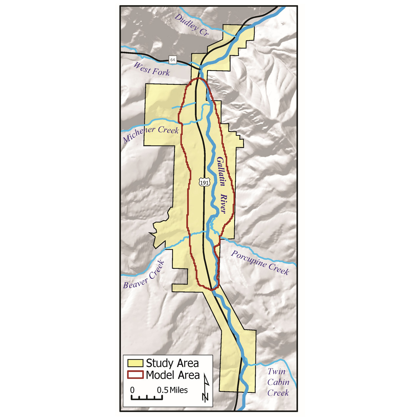
The Upper Gallatin River Corridor project focuses on the portion of Big Sky locally referred to as “the Canyon.” The study area is about 5 square miles and includes about a 7-mile reach of the Gallatin River, from its confluence with Twin Cabins Creek in the south to its confluence with Dudley Creek in the north. A groundwater model was developed within a portion of the study area (1.9 square miles) encompassing the most developed part of the alluvial aquifer.
Data Collected
Groundwater and surface water were monitored from 2019 to 2021 at several new and existing sites. Ten wells were drilled into the alluvial aquifer on the east and west sides of the Gallatin River to supplement the existing monitoring network. Aquifer tests were performed at two locations to determine the aquifer hydraulic characteristics (Rose, 2022). Gallatin River discharge was measured at four sites and discharge was also measured on Beaver, Porcupine, Levinski, Dudley, West Fork, and Mitchener Creeks, as well as two springs. Groundwater and surface-water samples were collected to evaluate water chemistry, particularly nitrate, within the study area. The MBMG collected 229 water-quality samples from 50 unique sites: 16 surface-water sites, 3 springs, and 31 well sites.
Hydrogeologic Framework
The alluvial aquifer is the primary focus of this project. The aquifer is a shallow, unconfined, water-bearing unit consisting of unconsolidated sands and gravels. The alluvium has an average thickness of approximately 35 ft and a maximum observed thickness of approximately 80 ft. The sands and gravels that make up the aquifer tend to thin and pinch out at the bedrock contacts along the margins of the study area. Depth to groundwater in the aquifer is generally between 5 and 40 feet below ground surface. The predominant recharge sources are snowmelt from the surrounding mountains and interaction with the Gallatin River and its tributaries. Some recharge also occurs through rainfall, and in some parts of the study area inflow occurs through bedrock.
Bedrock aquifers provide drinking water for some domestic wells and subdivisions. Water pumped from the bedrock aquifers is discharged via septic systems to the alluvial aquifer. In the northern and southern sections of the study area, where bedrock is closer to the surface and underlies the alluvial aquifer, there is likely groundwater flow from the bedrock to the alluvial aquifer.
Results
Water Quality
Results from the water-quality sampling show groundwater is generally suitable for human consumption; drinking water standards were only exceeded for strontium (two sites) and manganese for infants (four sites). Nitrate as nitrogen (nitrate-N) concentrations in groundwater were all below the 10 mg/L drinking water standard; the highest measured value was 5.1 mg/L. All surface-water samples had nitrate-N concentrations below 0.2 mg/L, except one sample (out of four) collected from the Gallatin River at Porcupine Road Bridge (0.76 mg/L on 10/21/2020), one sample (out of five) collected from the West Fork of the Gallatin River (0.49 mg/L on 2/18/2021), and several samples collected from Michener Creek. Michener Creek is a small stream that gains groundwater along the measured reach and had nitrate-N concentrations ranging from non-detect to 1.87 mg/L.
Groundwater Modeling
A steady-state groundwater model has been developed for the Gallatin River alluvial aquifer east of Big Sky Canyon Village and along HWY 191. Two time periods were modeled, one representing the low-flow conditions of 2020 and one representing the high-flow conditions of 2021. A water budget based on the model results provides estimates of groundwater recharge from precipitation, alluvial groundwater flow in from the south and out to the north, riparian evapotranspiration, septic system effluent inputs, and groundwater/surface-water interaction with the Gallatin River and its tributaries. The model was calibrated to measured groundwater elevations and to low-flow net stream gain–loss estimates. The calibrated model was used to perform “particle tracking” to delineate groundwater flow paths from potential nutrient sources to the river. Future uses of the model might include extending the model to simulate transient conditions and solute transport.
Project Reports
- Hydrogeologic investigation of the Upper Gallatin River Corridor, Big Sky, Montana
View Report - Groundwater model of the Upper Gallatin aquifer at Big Sky, Montana
View Report - Upper Gallatin River, Big Sky Canyon Area, Gallatin County, Ground Water Investigation Program, Project Update January 2025
View Report - Aquifer tests completed in the Upper Gallatin River Valley, Big Sky, Montana
View Report
Presentations
- Hydrogeologic Investigation and Groundwater Model of the Upper Gallatin Aquifer Upper Gallatin River Corridor, Big Sky, Montana. Presented at MT DEQ Gallatin River Project Open House, July 29, 2025.
View Presentation - Groundwater Study of the Upper Gallatin River Corridor. Presented Big Sky Water Collaborative Meeting, April 1, 2025.
View Presentation
Link to Project Data
Data collected for this project can be accessed through the Ground Water Information Center (GWIC) database:
Download project data from GWIC
Program Resources
Contact Information
Program Information
Ginette Abdo, GWIP Manager
(406) 496-4152 | Email