| Navigation | Equipment | Culbertson | White Cliffs | Great Falls | Gates of the Mountains | Three Forks | Beaverhead Rock | Pompeys Pillar | Terry |
Lewis and Clark in Montana — a geologic perspective
Gates of the Mountains
 The Lewis and Clark
Expedition spent a month near the falls of the Missouri River, then
continued upriver on July 15, 1805. Two days later they reached
the mountains and, on July 19, Lewis recorded:
The Lewis and Clark
Expedition spent a month near the falls of the Missouri River, then
continued upriver on July 15, 1805. Two days later they reached
the mountains and, on July 19, Lewis recorded:
. . . this evening we entered much the most remarkable clifts that we have yet seen. these clifts rise from the waters edge on either side perpendicularly to the hight of 1200 feet. every object here wears a dark and gloomy aspect. the tow[er]ing and projecting rocks in many places seem ready to tumble on us. the river appears to have forced it's way through this immence body of solid rock for the distance of 5¾ miles and where it makes it's exit below has thrown on either side vast collumns of rock mountains high. the river appears to have woarn a passage just the width of it’s channel or 150 yds. it is deep from side to side nor is ther in the 1st 3 miles of this distance a spot except one of a few yards in extent on which a man could rest the soal of his foot.
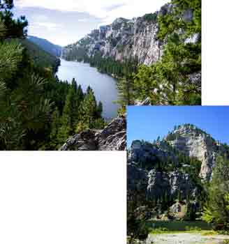
The cliffs that form the Gates of the Mountains, as Lewis noted, are about 5¾ miles in length, but rise about 1,000 feet above the water. For Lewis “evening” means “late afternoon,” at which time the entire west side of the gates and the eastern base would have been in shadow, possibly eliciting his description:
"every object here wears a dark and gloomy aspect."
The tow[er]ing and projecting rocks in many places seem ready to tumble on us.
Photos by Ginette Abdo, MBMG
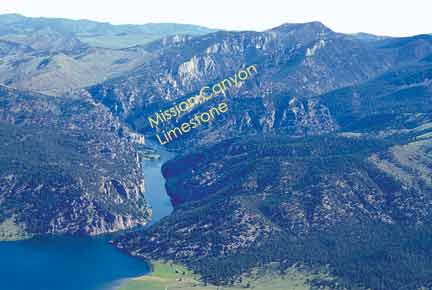
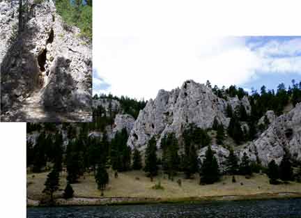
Gates of the Mountains area, looking north. The Missouri River began to shape this canyon 2 to 3 million years ago when it meandered over softer rocks that covered the rocks now exposed in the canyon. By the time the river cut into the harder rocks it was “trapped” in this course and carved the deep gorge we see today
Photo courtesy of Mitchell W. Reynolds,
U.S. Geological Survey
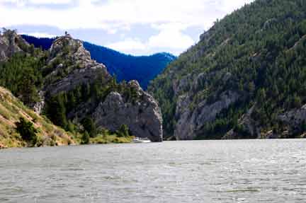
. . . from the singular appearance of this place I called it "the gates of the rocky mountains."
Seen from the downstream end of the Gates, great rock walls appear to block the river. As one draws nearer, however, the rock formations open to a deep, narrow gorge.
Photo courtesy of Michael Barth
. . . several fine springs burst out on the waters edge from the interstices
The interstices (openings) in the rock developed when groundwater, moving through fractures in the rock and reacting with the limestone, formed carbonic acid — which dissolves the limestone.
Holter Dam, constructed in 1918 about 10 miles downstream from the Gates of the Mountains, has raised water levels in the Gates by about 30 feet. The springs that Lewis noted are now underwater.
Photo courtesy of Michael Barth
. . . this rock is a black grannite below and appears to be of a much lighter colour above and from the fragments I take it to be flint of a yelloish brown and light creemcoloured yellow.
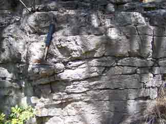
Photo by Ginette Abdo, MBMG
There is no granite in or adjacent to the Gates of the Mountains. The gorge is carved into rocks of Mississippian age, predominantly the Mission Canyon Limestone, which was deposited 325 million years ago when a shallow sea occupied much of Montana. This limestone was folded when the Rockies were being formed 70 to 65 million years ago, and great slabs of rock were thrust up and over other rocks.
The freshly broken, unweathered limestone
is dark gray. Seen in the shadow of the cliffs, it may have prompted
Lewis’s description of the black color. The exposed, weathered
limestone surfaces are lighter in color — cream to yellowish
orange.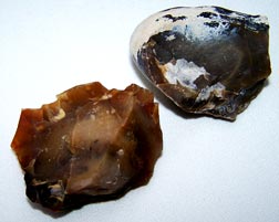
. . . flint of yelloish brown and light creemcoloured yellow.
By modern definition there is no flint in the Gates of the Mountains area. The upper section of the Mission Canyon Limestone, however, contains chert, and the term flint now refers to a variety of chert that is dark brown or black.
Photo by Ginette Abdo, MBMG
| Navigation | Equipment | Culbertson | White Cliffs | Great Falls | Gates of the Mountains | Three Forks | Beaverhead Rock | Pompeys Pillar | Terry |