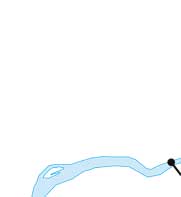
| Navigation | Equipment | Culbertson | White Cliffs | Great Falls | Gates of the Mountains | Three Forks | Beaverhead Rock | Pompeys Pillar | Terry |
Lewis and Clark in Montana — a geologic perspective
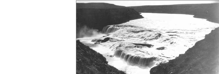
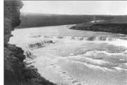
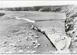
Great Falls of the Missouri
Meriwether Lewis left Clark at the Marias River on June 11, 1805 and set out to find the falls of the Missouri.
On June 13, while walking a mile north of that river:
. . . my ears were saluted with the agreeable sound of a fall of water and advancing a little further I saw the spray arrise above the plain like a collumn of smoke which would frequently dispear again in an instant . . . I did not however loose my direction to this point which soon began to make a roaring too tremendious to be mistaken for any cause short of the great falls of the Missouri.
 |
||||||||||||||||||
 |
||||||||||||||||||
 |
||||||||||||||||||
 |
||||||||||||||||||
| Courtesy Montana Historical Society |  |
|||||||||||||||||
 |
||||||||||||||||||
|
 |
|||||||||||||||||
 |
||||||||||||||||||
 |
||||||||||||||||||
 |
||||||||||||||||||
 |
||||||||||||||||||
 |
||||||||||||||||||
 |
||||||||||||||||||
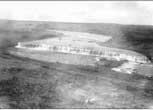
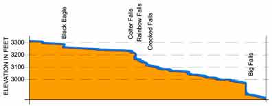
1.) About noon he reached Big Falls . . .
I hurryed down the hill which was about 200 feet high and difficult of access, to gaze on this sublimely grand specticle. I took my position on the top of some rocks about 20 feet high opposite the center of the falls. . . . the remaining part of about 200 yards on my right formes the grandest sight I ever beheld . . .
2.) Lewis headed upstream on the morning of June 14 to see how far the falls continued. About 5 miles from the Big Falls he:
. . .arrived at a fall of about 19 feet; the river is here about 400 yds. wide. this pitch which I called the crooked falls occupys about three fourths of the width of the river . . .
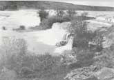
3.) Carefully noting the particulars of Crooked Falls, Lewis then . . .
. . . hearing a tremendious roaring above me I continued. . . a few hundred yards further and was again presented by one of the most beatifull objects in nature, a cascade of about fifty feet perpendicular streching at right angles across the river from side to side to the distance of at least a quarter of a mile. here the river pitches over a shelving rock, with an edge as regular and streight as if formed by art, without a nich or brake in it; the water decends in one even and uninterrupted sheet . . .
4.) It was near noon on June 14, when Lewis continued upstream from Rainbow Falls:
. . . I discovered another fall above at the distance of half a mile . . . I found this to be a cascade of about 14 feet possessing a perpendicular pitch of about 6 feet. . . . in any other neighbourhood but this, such a cascade would probably be extoled for it’s beaty and magnifficence, but here I passed it by with but little attention . . .
5.) After passing Colter Falls Lewis:
. . . arrived at another cataract of 26 feet. this is not immediately perpendicular, a rock about ⅓ of it’s decent seems to protrude to a small distance and receives the water in it’s passage downwards and gives a curve to the water tho’ it falls mostly with a regular and smoth sheet. the river is near six hundred yards wide at this place . . . below this fall at a little distance a beatifull Island well timbered is situated about the middle of the river. in this Island on a Cottonwood tree an Eagle has placed her nest; a more inaccessable spot I beleive she could not have found . . .
Creating the Falls
Start with the rocks
Rivers flowing from the west deposited alternating
layers of sand, silt, and mud on the coastal plain and shore of a
sea that occupied this area during the Early Cretaceous Period. These
sediments became the sandstone, siltstone, and mudstone of the middle
part of the Kootenai Formation.
The Sunburst Sandstone
at Big Falls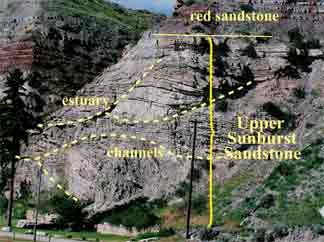
The Sunburst Sandstone (deposited
120 million years ago) is a resistant sandstone at the
base of the middle Kootenai Formation. Deposits typical
of tidal channels and estuaries have been identified in
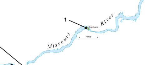
these rocks and can be seen north of Ryan Island Park.
The height of Big Falls (about 90 feet) is partly due to
the thickness of the Sunburst Sandstone there.
| Middle Kootenai Formation near Ryan Island Park and Big Falls |
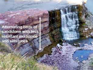
Beds overlying the Sunburst — the upper falls
The middle Kootenai Formation rocks
that overlie the Sunburst Sandstone are alternating layers
of thin sandstone and less resistant siltstone and mudstone.
The sediments were deposited in stream beds and interstream
areas inland from the shore on a coastal plain or delta plain;
they show no evidence of marine conditions.
 Crooked, Rainbow, Colter, and Black
Eagle falls cascade over these rocks.
Crooked, Rainbow, Colter, and Black
Eagle falls cascade over these rocks.
MBMG
Bring on the Glaciers
About 15,000 years ago glacial ice
advanced just south of Great Falls, burying the Missouri’s
valley. When the ice retreated, the Missouri River cut a
new channel between Sand Coulee Creek and Box Elder Creek
(see map). Torrents of water began draining through this
new channel.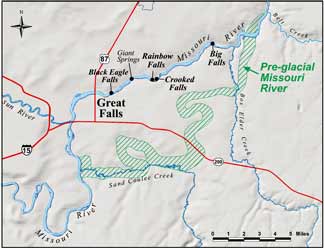
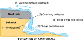
Post-Glacial Erosion
The Missouri cut its new channel
through resistant sandstone interbedded with less resistant
siltstone and mudstone. Waterfalls formed
as the river flowed over the jointed and fractured rock.
Eventually falling water undercuts the more resistant sandstone
layers and, as the undercut enlarges, the sandstone collapses
along joint surfaces. This process continues and the waterfall
moves upstream.
MBMG
Lewis and Clark might be amazed at how little water sometimes flows over the falls today — five dams control flow along this section of the Missouri.
MBMG
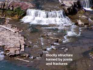
Layers of maroon-colored mudstone and siltsone in the Kootenai Formation form the Black Eagle Falls. Flowing water cuts into the less resistant beds, undermining the more resistant ones.
The much-reduced flow of water over Black Eagle Falls provides a good view of the layering in the Kootenai Formation and also the blocky structure produced by jointing and fracturing. Water flowing along the joints and fractures contributes to the development of the falls.
Photos by Ginette Abdo, MBMG
| Navigation | Equipment | Culbertson | White Cliffs | Great Falls | Gates of the Mountains | Three Forks | Beaverhead Rock | Pompeys Pillar | Terry |