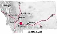
| Navigation | Equipment | Culbertson | White Cliffs | Great Falls | Gates of the Mountains | Three Forks | Beaverhead Rock | Pompeys Pillar | Terry |
Lewis and Clark in Montana — a geologic perspective
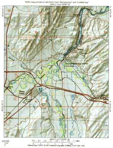
Three Forks of the Missouri
 Upstream
from the Gates of the Mountains the river cliffs became lower, and
a few miles south of present-day Canyon Ferry, the mountains stood
miles from the river. In this wide valley on July 22, 1805, Sacagawea
recognized a place where her Shoshone relatives dug a white soil
to make ceremonial paint. She also assured Lewis that the Three Forks
of the Missouri were “at no great distance."
Upstream
from the Gates of the Mountains the river cliffs became lower, and
a few miles south of present-day Canyon Ferry, the mountains stood
miles from the river. In this wide valley on July 22, 1805, Sacagawea
recognized a place where her Shoshone relatives dug a white soil
to make ceremonial paint. She also assured Lewis that the Three Forks
of the Missouri were “at no great distance."
 Clark set out the next morning with four
men to look for the Shoshone again, hoping to obtain horses to
cross the mountains to Pacific waters. He arrived at the Three
Forks early on July 25, then explored the Jefferson and Madison
rivers before rejoining the main party on the 27th, ill and with
a high fever.
Clark set out the next morning with four
men to look for the Shoshone again, hoping to obtain horses to
cross the mountains to Pacific waters. He arrived at the Three
Forks early on July 25, then explored the Jefferson and Madison
rivers before rejoining the main party on the 27th, ill and with
a high fever.
Lewis and the main party made camp on July 26 about seven miles down river from the Three Forks. The next morning, July 27, while continuing upstream, Lewis noted:
. . . the river was again closely hemned in by high Clifts of a solid limestone rock which appears to have tumbled or sunk in the same manner as those discribed yesterday
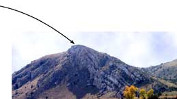
About a mile west (upstream) from Lewis’s July 26 camp, limestones of the Madison Group form the outcrops along both sides of the Missouri River. These limestones were deposited in a shallow sea that occupied the Rocky Mountain region during the Mississippian Period (about 325 million years ago). During the Late Cretaceous Period (about 100 to 65 million years ago), these marine rocks were folded, faulted, and uplifted by mountain-building processes.
 |
||
 |
 |
|
Photos by Ginette Abdo, MBMG |
 |
|
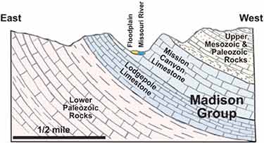
Geologic cross section showing the dipping beds that may have appeared to Lewis “to have tumbled or sunk."
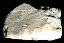 |
Note the “ light led colour” of the weathered limestone
|
The “deep blue colour” is
Photos by Ginette Abdo, MBMG. |
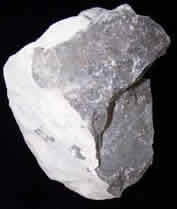 |
. . . the limestone appears to be of an excellent quality of deep blue colour when fractured and of light led colour where exposed to the weather. it appears to be of a very fine gr[a]in and the fracture like that of marble.
The limestone Lewis described is part of the Mission Canyon Formation, the upper member of the Madison Group limestones. Notice the difference in color that Lewis observed between the weathered and unweathered (fresh) pieces of the limestone
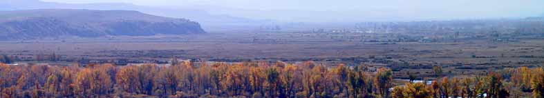
. . . we arrived at 9 A.M. at the junction of the S.E. fork of the Missouri and the country opens suddonly to extensive and beatifull plains and meadows which appear to be surrounded in every direction with distant and lofty mountains; supposing this to be the three forks of the Missouri I halted the party on the Lard. shore for breakfast and walked up the S. E. fork about ½ a mile and ascended the point of a high limestone clift from whence I commanded a most perfect view of the neighbouring country.
From the top of the "high
limestone cliff", Lewis had a magnificent view of the Gallatin,
Madison, and Jefferson rivers, the extensive plains surrounding
them, and the snowcapped peaks of the Bridger, Gallatin, Madison,
and Tobacco Root ranges. Faulting in western Montana during the
early and middle Tertiary Period (55–20 million 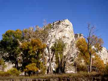 years ago)
raised some blocks of the earth's crust and down-dropped others.
Sediments from the raised blocks (now the mountain ranges) washed
into the down-dropped blocks (intermontane valleys), partly filling
them to form the "extensive plains" that Lewis described.
years ago)
raised some blocks of the earth's crust and down-dropped others.
Sediments from the raised blocks (now the mountain ranges) washed
into the down-dropped blocks (intermontane valleys), partly filling
them to form the "extensive plains" that Lewis described.
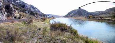
From this vantage point, atop Lewis’s Rock, Lewis observed:
between the middle and S. E. forks near their junction with the S.W. fork there is a handsom site for a fortification it consists of a limestone rock of an oblong form; it's sides perpendicular and about 25 ft high except at the extremity towards the middle fork where it ascends gradually and like the top is covered with a fine terf or greenswoard. the top is level and contains about 2 Acres. the rock [r]ises from the level plain as if it had been designed for some such purpose.
The limestone rock Lewis described, called
Fort Rock, is a broad outcrop of Mission Canyon limestone. This generally
flat-topped feature is 2800 feet long by 800 feet wide and rises
a little more than 40 feet above the floodplain. The long axis of
the outcrop trends southwest–northeast, approximately paralleling
a thrust fault (from the mountain-building episode). The Gallatin
River forms the eastern boundary of the feature, separating it from
Lewis’s Rock.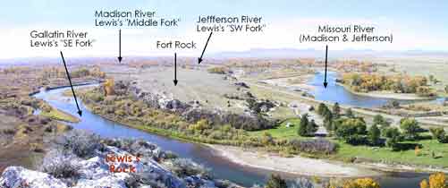
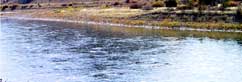
Looking southwest from Lewis’s Rock. The three rivers have shifted course many times since 1805. Today, where the Madison and Jefferson forks meet, the Missouri River begins, joined a short distance downstream (to the right of the photo) by the Gallatin River
Photo by Ginette Abdo, MBMB
Lewis set up camp on the Jefferson just upstream from its junction with the Madison River. Convinced that the Three Forks was an essential point in the geography of western part of North America, he wanted to take celestial observations to obtain its latitude and longitude.The party camped here for three nights before ascending the Jefferson River.
Three Forks Area
MBMG
| Navigation | Equipment | Culbertson | White Cliffs | Great Falls | Gates of the Mountains | Three Forks | Beaverhead Rock | Pompeys Pillar | Terry |