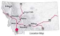
| Navigation | Equipment | Culbertson | White Cliffs | Great Falls | Gates of the Mountains | Three Forks | Beaverhead Rock | Pompeys Pillar | Terry |
Lewis and Clark in Montana — a geologic perspective
Beaverhead Rock
Meriwether Lewis completed his celestial observations at the Three Forks of the Missouri about 8:30 pm on July 29, 1805. The next morning, the Corps of Discovery headed up the Jefferson River. On August 1, Lewis and three men began scouting ahead on foot; they reached the three forks of the Jefferson River on August 3. Clark, with the canoes, joined them on August 6.
Lewis named the Jefferson River’s southeast fork Philanthrophy River (now Ruby River) and the southwest fork Wisdom River (now Big Hole River) in “commemoration of two of those cardinal virtues, which have eminently marked that deservedly selibrated character [Thomas Jefferson] through life.” The captains decided to follow the Jefferson River (now Beaverhead River), believing that it would provide the best route over the mountains to the Columbia River.
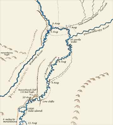 Lewis recorded that on August 8, Sacagawea
. . .
Lewis recorded that on August 8, Sacagawea
. . .
. . . recognized the point of a high plain to our right which she informed us was not very distant from the summer retreat of her nation on a river beyond the mountains which runs to the west. this hill she says her nation calls the beaver’s head from a conceived remblance of it’s figure to the head of that animal . . .
On August 10, while Lewis again scouted ahead, Clark passed Beaverhead Rock with the canoes:
. . . we proceeded on passed a remarkable Clift point on the Stard. Side about 150 feet high, this Clift the Indians Call the Beavers head, opposite at 300 yards is a low clift of 50 feet which is a Spur from the Mountain on the Lard. about 4 miles . . .
Clark’s
map of the Beaverhead Rock area modified
by Bob Bergantino, MBMG
| Southeast | Northwest |
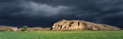 |
|
| Photo courtesy of Brent Phelps | |
With the help of a little imagination a
beaver’s head can be seen in the cliff on the right. The
rock cliff on the left side of the river is not structurally or
topographically related to the Ruby Mountains to the east; that
is, it is not a spur from them as Clark thought. The summit of
Beaverhead Rock actually stands about 380 feet above the river,
that is, 230 feet higher than Clark’s estimate.
| North | South |
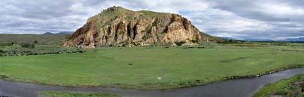 |
|
| Photo courtesy of Ginette Abdo, MBMG | |
Ages before Lewis and Clark arrived, Beaverhead Rock was a well known landmark to Native Americans of this area. The “Rock” is composed of gently west-dipping Mississippian-age Mission Canyon Limestone — the same formation exposed in the Gates of the Mountains and near the Three Forks of the Missouri. Deposited over 325 million years ago in a shallow sea that covered much of interior North America, the Mission Canyon Limestone (part of the Madison Group of limestones) crops out in many mountain ranges in Montana.
Faulting in this area several million years ago raised a block of the earth’s crust. As the Beaverhead River eroded the softer, younger deposits that capped and surrounded the fault block, the more resistant Mission Canyon Limestone remained as a prominent cliff.
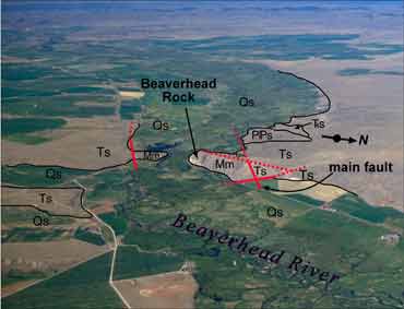 Qs Sediments
of modern streams, flood plain and lower slopes
Qs Sediments
of modern streams, flood plain and lower slopes- Ts Sediment and sedimentary rock of Tertiary Period (2.5-65 million years ago)
- TRs Sedimentary rock of Triassic Period (206-248 million years ago)
- PlPs Sedimentary rocks of Permian and Pennsylvanian Periods (248-325 million years ago)
- Mm Sedimentary rocks (Mission Canyon Limestone) of Mississippian Period (325-354 million years ago)
- _____ Contacts
- ----- - - Faults, dashed where covered
Air photo courtesy of Hugh Dresser
| Navigation | Equipment | Culbertson | White Cliffs | Great Falls | Gates of the Mountains | Three Forks | Beaverhead Rock | Pompey's Pillar | Terry |