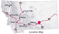
| Navigation | Equipment | Culbertson | White Cliffs | Great Falls | Gates of the Mountains | Three Forks | Beaverhead Rock | Pompeys Pillar | Terry |
Lewis and Clark in Montana — a geologic perspective
Pompey's Pillar
 Lewis
and Clark split the expedition into two exploring parties at Travelers
Rest near present-day Lolo, Montana on July 3, 1805. They planned
to rejoin at the mouth of the Yellowstone River. Clark’s
party included Sacagawea and little Jean Baptiste. One of Clark’s
objectives was to explore the Yellowstone River. About 25 miles
southwest of present-day Billings, Clark’s party
built dugout canoes; they launched them on July 24. By mid-afternoon
on July 25, the canoes had traveled more than 50 miles down river
to the northeast:
Lewis
and Clark split the expedition into two exploring parties at Travelers
Rest near present-day Lolo, Montana on July 3, 1805. They planned
to rejoin at the mouth of the Yellowstone River. Clark’s
party included Sacagawea and little Jean Baptiste. One of Clark’s
objectives was to explore the Yellowstone River. About 25 miles
southwest of present-day Billings, Clark’s party
built dugout canoes; they launched them on July 24. By mid-afternoon
on July 25, the canoes had traveled more than 50 miles down river
to the northeast:
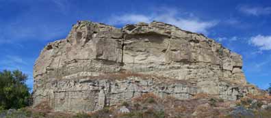
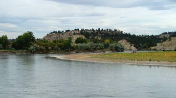
. . . at 4 P M arrived at a remarkable rock Situated in an extensive bottom on the Stard. Side of the river & 250 paces from it. this rock . . . I shall Call Pompy’s Tower is 200 feet high and 400 paces in secumphrance and only axcessable on one Side which is from the N.E. the other parts of it being a perpendicular Clift of lightish Coloured gritty
Clark likely named
this feature for Jean Baptiste Charbonneau, nicknamed Pomp. In
the first edition of the History of the Lewis and Clark Expedition
(1814), however, the name 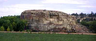 became Pompeys Pillar. The pillar was
proclaimed a National Monument in 2001.
became Pompeys Pillar. The pillar was
proclaimed a National Monument in 2001.
The height of the pillar is about 130 feet, substantially lower than Clark’s estimated 200 feet. Its base is oval-shaped, about 370 feet by 480 feet, and is nearly 400 yards around.
Photo by Ginette Abdo, MBMG
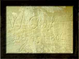 Lewis and Clark left few physical marks on the land as they passed.
Clark’s engraved signature on Pompeys Pillar is one of them.
Rain, wind and frost wear away the soft sandstone that forms
this Pillar, and inscriptions soon fade unless deeply incised.
Lewis and Clark left few physical marks on the land as they passed.
Clark’s engraved signature on Pompeys Pillar is one of them.
Rain, wind and frost wear away the soft sandstone that forms
this Pillar, and inscriptions soon fade unless deeply incised.
Clark’s original signature still could be read in 1876, but has been re-engraved several times. It now is enclosed and protected.
The nativs have ingraved on the face of this rock the figures of animals &c. near which I marked my name and the day of the month & year.
Photo by Ginette Abdo, MBMG
|


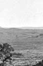
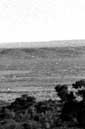


W.R. Plywell, with the Stanley
Expedition (1873), photographed Pompeys Pillar from the cliffs north of the river. Today trees obscure the Pillar from this site.
Photo (no. 106-YX-36) courtesy of the National Archives
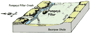
How did the Pillar Form?
 About 65 million years
ago, during the Late Cretaceous Period . . .
About 65 million years
ago, during the Late Cretaceous Period . . .
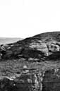
. . . rivers flowing eastward from the rising Rocky Mountains carried sand, silt, and clay to a shallow sea just east of present-day Montana. The sand and silt those rivers deposited here became, with time and compaction, the lightish Coloured gritty rock that Clark described. Geologists call this the Lance Formation.
Photo by Ginette Abdo, MBMG
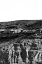
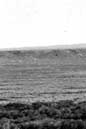
Several million years ago . . .
. . . the Yellowstone River meandered over its flood plain much as it does now, gradually cutting its valley deeper. What is now Pompeys Pillar was once part of the cliffs north of the river.
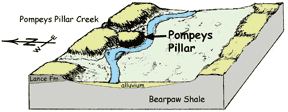 |
A meander began to eat into the cliff north of the present Pillar, forming a low neck. Pompeys Pillar Creek also cut into the weak rock there.
MBMG |
Then, likely during a flood, the river breached the low neck, separating the Pillar from the cliffs north of the river, isolating it on the south side.
MBMG |
 |
the rib of a fish. . .
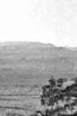
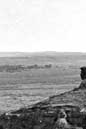
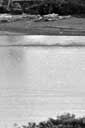
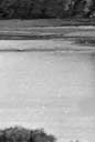
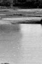
About 6 miles down river from Pompeys Pillar forty bighorn sheep crowded the cliff north of the river. The canoes landed and Clark climbed the cliff. Near the top Clark found a bone protruding from the soft rock
 . . . I employed
my Self in getting pieces of the rib of a fish which
was Semented within the face of the rock This rib
is [about 3] inchs in diame Secumpherance about the
middle… it is 3 feet in length
tho a part of the end appears to have been broken off.
I have Several pieces of this rib the bone is neither
decayed nor petrified but very rotten.
. . . I employed
my Self in getting pieces of the rib of a fish which
was Semented within the face of the rock This rib
is [about 3] inchs in diame Secumpherance about the
middle… it is 3 feet in length
tho a part of the end appears to have been broken off.
I have Several pieces of this rib the bone is neither
decayed nor petrified but very rotten.
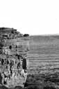
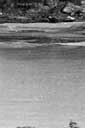
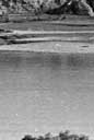
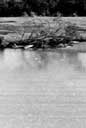
Rocky cliff that Clark may have climbed..
Photo by Ginette Abdo, MBMG
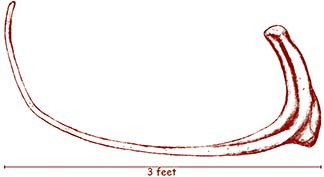
The bone is from a terrestrial dinosaur — perhaps a Triceratops or Tyrannosaurus. The rock that held this bone is part of the Lance Formation (Cretaceous). Dinosaurs were not recognized as a distinct group of animals until 1840.
Reconstruction of
the “rib of a fish” from Clark’s description
and a small sketch he made on a map of this area
—Bob Bergantino, MBMG
| Navigation | Equipment | Culbertson | White Cliffs | Great Falls | Gates of the Mountains | Three Forks | Beaverhead Rock | Pompeys Pillar | Terry |