| Navigation | Equipment | Culbertson | White Cliffs | Great Falls | Gates of the Mountains | Three Forks | Beaverhead Rock | Pompeys Pillar | Terry |
Lewis and Clark in Montana — a geologic perspective
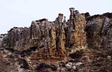
The White Cliffs of the Missouri
Lewis and Clark entered
the Missouri Breaks on May 9, 1805 at present-day Fort Peck. Rugged
topography and rock outcrops flank the Missouri throughout the
Breaks, but the most spectacular scenery and geology are in the White
Cliffs of the Missouri.
Lewis described this area on May 31:
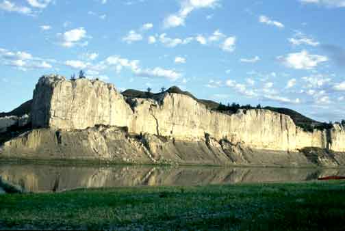
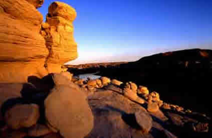
The hills and river Clifts which we passed today exhibit a most romantic appearance. The bluffs of the river rise to the hight of from 2 to 300 feet and in most places nearly perpendicular; they are formed of remarkable white sandstone which is sufficiently soft to give way readily to the impression of water . . .
Photo courtesy of Otto L. Schumacher
The "remarkable white sandstone" is the Virgelle Member of the Eagle Formation. Rivers deposited it as sand during the Cretaceous Period when a shallow sea covered much of interior North America. The sandstone contains many vertical cracks. Erosion and weathering widen the cracks, weakening the rock. Eventually slabs fall off, leaving near-vertical cliffs. The dark formation below the Virgelle is the Marias River Shale.
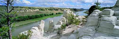
The water in the course of time . . . has trickled down the soft sand clifts and woarn it into a thousand grotesque figures
Photo courtesy of Brent Phelps
Lewis, May 31, 1805
. . . with the help of less immagination we see the remains or ruins of eligant buildings; some collumns standing and almost entire with their pedestals and capitals . . .
Hard sandstone in the upper part of the Eagle Formation caps the Virgelle Member, protecting it from erosion. Without the cap rock the softer Virgelle sandstone erodes readily.
Photo by Ginette Abdo, MBMG
The hills and river Clifts which we passed today exhibit a most romantic appearance.
Photo courtesy of Wayne
Mumford
(www.waynemumford.com)
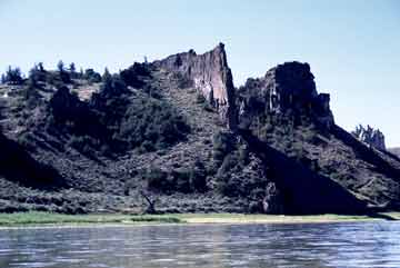
Grand Natural Wall is one of many dikes that formed when magma forced its way into joints in the sedimentary rock. The dike rock here is more resistant than the surrounding sedimentary rock.
As we passed on it seemed as if those seens of visionary inchantment would never have and end; for here it is too that nature presents to the view of the traveler vast ranges of walls of tolerable workmanship . . .
Photo courtesy of Otto L. Schumacher
Lewis apparently did not realize that the dikes once were molten. He commonly identified most shiny crystals as talc or quartz, possibly considering them related minerals.
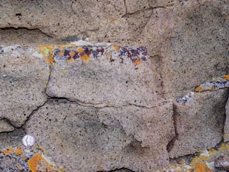
. . .these stones are almost invariably regular parallelepipeds, of unequal sizes in the walls, but equal in their horizontal ranges, at least as to debth.
Shown is the parallelepiped shape Lewis noted; it results when cracks form as lava cools.
Photo by Ginette Abdo, MBMG
The Making of a Landscape
 From sediment to rock
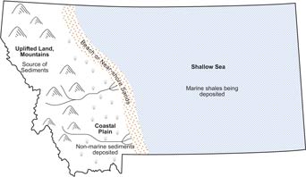
A shallow sea occupied
the North American interior from 150 to 65 million years ago. When
the Rocky Mountains began rising, rivers carried sediments eastward
from them to this sea, depositing sand near its shore, silt and
clay farther east in deeper water. Continued deposition buried
the earlier sediments. Pressure and cementing solutions then changed
sand, silt, and clay into sandstone, siltstone, and shale. Joints
and cracks developed in these rocks.
MBMG
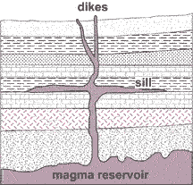
Vulcanism
About 50 million years ago
molten rock from deep within the earth rose up through joints in
the overlying sedimentary rocks.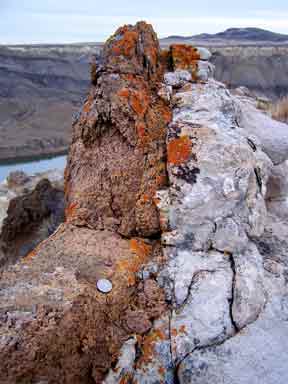 Erosion has removed most of the
volcanic outpouring, but the river cliffs here expose numerous
near-vertical dikes.
Erosion has removed most of the
volcanic outpouring, but the river cliffs here expose numerous
near-vertical dikes.
Contact
between a dike (brown)
and sandstone (light-gray)
MBMG
Photo by Ginette Abdo, MBMG
Rivers re-routed
Glacial ice entered northern Montana
several times during the ice ages (2 million to 10,000 years
ago). About 160,000 to 130,000 years ago, ice blocked the Missouri’s
course northeast of Great Falls. Lakes formed in the rivers south
of the ice. 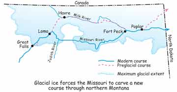 Lake levels rose until their waters cut channels into
adjacent drainages. Ultimately, the entire flow of the Missouri
was rushing eastward in a new valley, carving and deepening it
as it went. Smaller streams later occupied much of the Missouri’s
former valley.
Lake levels rose until their waters cut channels into
adjacent drainages. Ultimately, the entire flow of the Missouri
was rushing eastward in a new valley, carving and deepening it
as it went. Smaller streams later occupied much of the Missouri’s
former valley.
MBMG
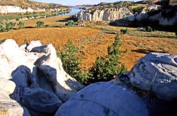
Erosion
The Missouri River in the upper
Breaks area is still carving its new course, as evidenced by the
valley walls that are steeper than those along its preglacial course.
Photo
courtesy of Wayne Mumford
(www.waynemumford.com)
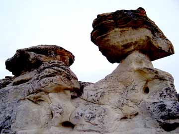
A drop of rain, a downpour, wind, frost, running water . . . all erode the soft Virgelle sandstone, carving it into the "thousand grotesque figures"
Photo by Ginette Abdo, MBMG